Camila Zenke
💻 Group Product Manager | Maps Platform on iFood
This post was co-written by
Christian Zambra
💻Product Manager - AI in Logistics at iFood
Hey guys! We prepared this article to show a little about how the use of Remote Sensing and Artificial Intelligence can be applied in the delivery sector!
To Feed the Future of the World through meal delivery, we balance three agents: Customers, Delivery Persons and Restaurant Partners. A crucial indicator for such balance is demand. The number of orders is essential for both our partners and the delivery person, and for the latter, the location of the orders can directly influence their experience. Therefore, identifying the locations where there is demand for our services can represent the difference between success or failure of a delivery.
In this project, we tell you a little about how to use Remote Sensing and Artificial Intelligence to help us map out which places have the greatest potential for providing the best possible delivery experience!
Remote Sensing and Artificial Intelligence, what is it?!
Remote Sensing, in short, can be defined by the systematic acquisition of images of the Earth's surface through satellites, radars, drones, planes and even balloons. This data is used, for example, in the environmental and agricultural sectors for monitoring forests and crop planning. But the number of applications through Science is growing when we talk about cities and urban mobility.
People leave footprints, and some footprints can be seen from the sky. This metaphorical phrase reflects a truth: Human beings have altered the environment where they live in such a significant way that each inhabited part of this world has its own identity: the streets, in their cores and formats; the houses, ranging from the roof to the presence or absence of a backyard... And even from outside the Earth, satellites can record these geographic expressions of inhabitants in “images” even in the most remote places on the planet.
As satellite images change our way of seeing the world, it begins to be seen “from above”. With them, we can discover places using just our computer screen! Look at the roof of our house or consider our street. Play with time and visit what places were like in our childhood. Plan a trip by visiting tourist attractions and measuring the distance between them.
And through this technology, we are able to map where cities are, whether large or small, anywhere in the world. This type of knowledge allows us to monitor, quantify, measure and understand places and their urban dynamics, such as the growth of the Municipality of Itaboraí, in the State of Rio de Janeiro, between 2007 and 2020.
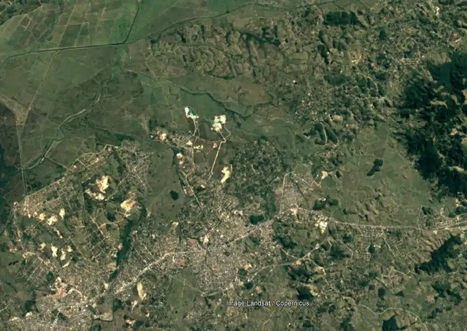
Itaboraí, RJ — 2007. Source: Google Earth.
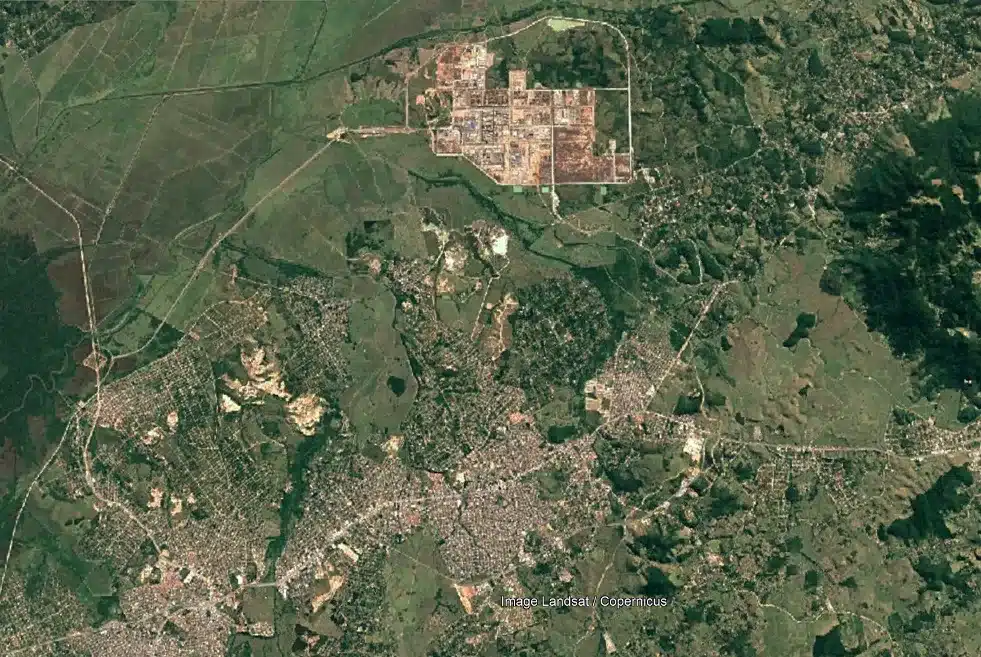
Itaboraí, RJ — 2020. Source: Google Earth.
We believe that each place has characteristics that can give us clues about your willingness to order delivery or not, so we seek to predict the consumption potential of each small town mapped using Remote Sensing. We don't know what these tips are, but we believe that artificial intelligence algorithms can discover them. Thus, with artificial intelligence, we can know how much portions of the inhabited space are willing to order delivery on iFood!
To achieve this, we started developing a tool that uses Convolutional Neural Networks. This technology is the basis of many popular applications linked to photography. There are algorithms that are capable of, when observing an image, identifying the presence of objects or animals, for example. To do this, the technology replicates what our brains do: When we look at an image, we classify it.

https://www.stockvault.net/photo/285204/pretty-calico-cat
Public domain image
Imagine a photo, with a kitten in the middle. How do you know it's a kitten? Your brain identifies something in the photo, and starts analyzing details. Analyze the snout, ears, eyes, and based on these details, classify the kitten as a kitten.
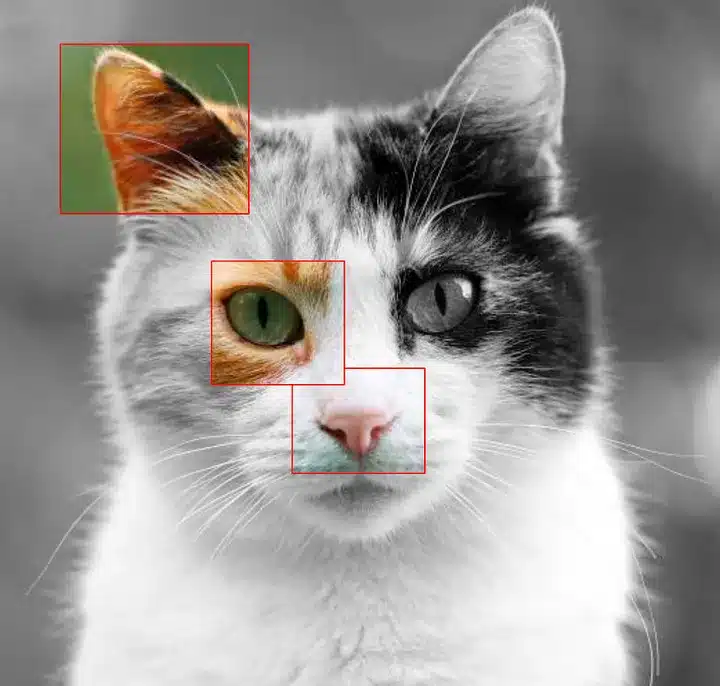
In a similar way, our artificial intelligence analyzes satellite image details and classifications. Like kittens, we identify the regions where there is potential for consumption of iFood services and so we can offer the best delivery experience for each city!
We're just getting started!
Here at iFood, these solutions have generated increasingly more value: For the company, investing in the right place brings savings and predictability. For the customer, receive the iFood experience, hot food at the right time or your monthly purchases, at your home. For a delivery person, operating in a region that will bring orders and financial gains, and for the restaurant or supermarket, increasing the number of orders consistently.
In addition to the immediate results, the journey brought us great lessons, which will give rise to new products combining geographic and artificial intelligence, but we will leave that to tell in another story, after all, we are just getting started!
Thanks:
Special thanks to the people who make this entire journey possible and fun:
Location | Logistics:
Specialist Product Manager: Camila Zenke.
Group Product Manager: Elvis Oliveira .
Software Engineering Manager: Juliane Mazucki .
Software Engineers: João Lello, Leonardo Schick, Alexandre Miyaura , Douglas Lins , Anderson Luciano , Rogério Miranda , Kevin Uehara and Jair Bressani.
Head of Engineering: Jamilson Batista.
Design Manager: Giovanna Baltazar .
Product design: Jonathan Narrone .
AI | Logistics:
AI Product Manager: Christian Zambra .
Group Product Manager: Thiago Capeleiro It is Wellington Brosko .
Data Scientists: Igor Bastos , Rubens Eiji It is Leonardo Toledo .
Head of AI: Arnaud Seydoux .
Design Manager: Giovanna Baltazar .
Want exclusive content created by our technology-driven times? Sign up.
Writers: Camila Zenke and Christian Zambra